 NUMBER FIFTY
Oregon & Northern California
14 – 22 July 2011
Having visited every continent and forty-nine states, we planned a trip to Oregon, the only state in which we had never set foot. Luckily for us, the high temperatures in Oregon were running a good twenty degrees below those in Southlake. Thursday was the thirteenth consecutive triple-digit-day in a summer already the second hottest on record.
Thursday 14 July – We flew from DFW to Portland, Oregon. Upon arrival, we rented a car, set the GPS for the hotel and left around 3:00. We took I-205 to I-5 and drove south. Sharing the road with 18-wheelers with triple trailers was a new experience; here they are confined to the right-hand lane and a lower speed limit. We really didn’t see anything of the city and were soon in an agricultural area. Other than one herd of sheep and another of yearling calves, we saw hay. Acres and acres of mown grass were windrowed and awaiting baling. The GPS directions guided us directly to The Residence Inn in Eugene. This being Thursday, they served a light supper beginning at 5:00; tonight was salad night.
Thursday 14 July – We flew from DFW to Portland, Oregon. Upon arrival, we rented a car, set the GPS for the hotel and left around 3:00. We took I-205 to I-5 and drove south. Sharing the road with 18-wheelers with triple trailers was a new experience; here they are confined to the right-hand lane and a lower speed limit. We really didn’t see anything of the city and were soon in an agricultural area. Other than one herd of sheep and another of yearling calves, we saw hay. Acres and acres of mown grass were windrowed and awaiting baling. The GPS directions guided us directly to The Residence Inn in Eugene. This being Thursday, they served a light supper beginning at 5:00; tonight was salad night.
Friday 15 July – We left around 8:00. Unlike yesterday’s mostly overcast skies, today’s were mostly clear with only a few puffy, white, cottony clouds. It was cool and we put our jackets in the back seat. We headed south on I-5 and spent the next three or so hours going up and down mountainous roadway in a valley. Elevations ranged to almost 2000 feet at times. We saw more agriculture but today it was mostly small farms. We did see some dairies and some more flocks of sheep. When we stopped for gas at Rosenberg, we learned that it is illegal to pump your own gas in Oregon. We left I-5 at Grant’s Pass and took Highway 99/100 aka The Redwood Highway as we angled west toward the coast and south toward California. We detoured at Grant’s Pass to the Applegate Valley and went to a couple of wineries. A large dairy occupies a part of the creek bottom and sprays liquid manure to fertilize---very smelly. Then it was time to drive the fourteen miles back to Highway 199. Just before reaching the highway again, we stopped for lunch. After eating, we headed for Redwood Country and wended our way through Southern Oregon seeing more mountainous terrain; at one point we were stopped for 10 minutes by a construction flagman waiting for sixty-seven vehicles to pass and there must have been that many behind us---all to be led by a vehicle for seven-tenths of a mile as a crew worked on a power line off the side of the road. We entered California and went through a short tunnel before beginning a swirling, twisting, turning drive along a highway carved along the side of the mountains as we made our way up and down through heavily forested terrain. Occasionally streams of sparkling water rushed along beside the roadway. After traversing the Smith River National Recreation Area, we continued southwesterly until we reached the Jedediah Smith Redwoods State Park; here we saw large redwood trees along the roadside. After leaving that park, we merged into Highway 101 near Crescent City and made our way south along the coast. As we drove, we marveled at the view; in some places the waves, clouds, and sky became bands of color-changing hues. 
 We saw more redwoods in places and stopped at one overlook to make some photos of the coast.
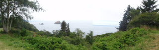 Occasional patchy fog obscured the tops of trees adding to the atmosphere. Knowing we would return this way, we took no side trips. At Kuchel Visitor Center just south of Orick, we got a map and touring advice from a park ranger. It was almost 5:00 when we arrived at our hotel in Eureka.
Saturday 17 July –About 9:00 we left and took Highway 101 south to see the giant redwoods. We exited 101 at Pepperwood and entered the Avenue of the Giants, a 31-mile long stretch of roadway along the Eel River. The scenic country road meanders through some stands of giant redwoods and has easy access to Highway 101; along the way are signs denoting specific groves and dedicated areas. Convenient parking areas provide places to stop, get out, and walk in the woods. We did that at Crury-Chaney Grove shortly after entering the roadway: standing beneath the towering trees; beside the huge trunks; next to gigantic stumps; eyeing the lengthy logs of downed trees. The calm, cool, darkness provides a refreshing atmosphere. Photographs are inadequate. Of course, the road winds in and out of the redwood groves but in many places the vista of an insignificant ribbon of asphalt winding through a tunnel composed of huge grayish columns with tops that almost touch to prevent any sunlight pervades.


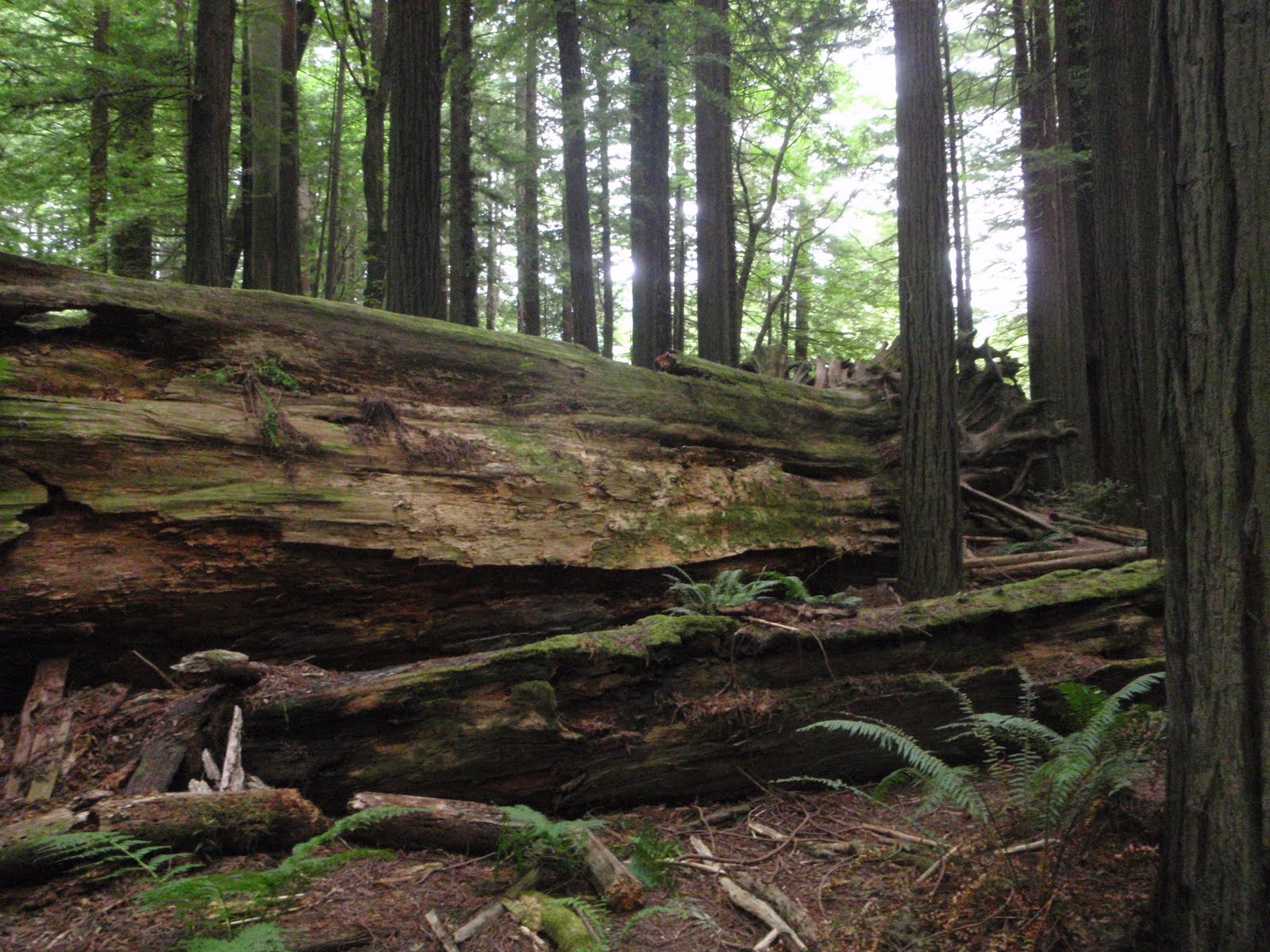


In some areas, the Eel River, a wide, gravel-strewn area with only a narrow rivulet of water, becomes visible. We stopped for lunch at Rio Café. At Myer’s Flat, we paid $6 and drove through the Shrine Drive Thru Tree and made some photos.


After exiting the Avenue of the Giants near Phillipsville, we took Highway 101 north and exited near Weott. Returning to the scenic area, we went to Founders Grove where we walked a half-mile –long-trail through the redwoods.


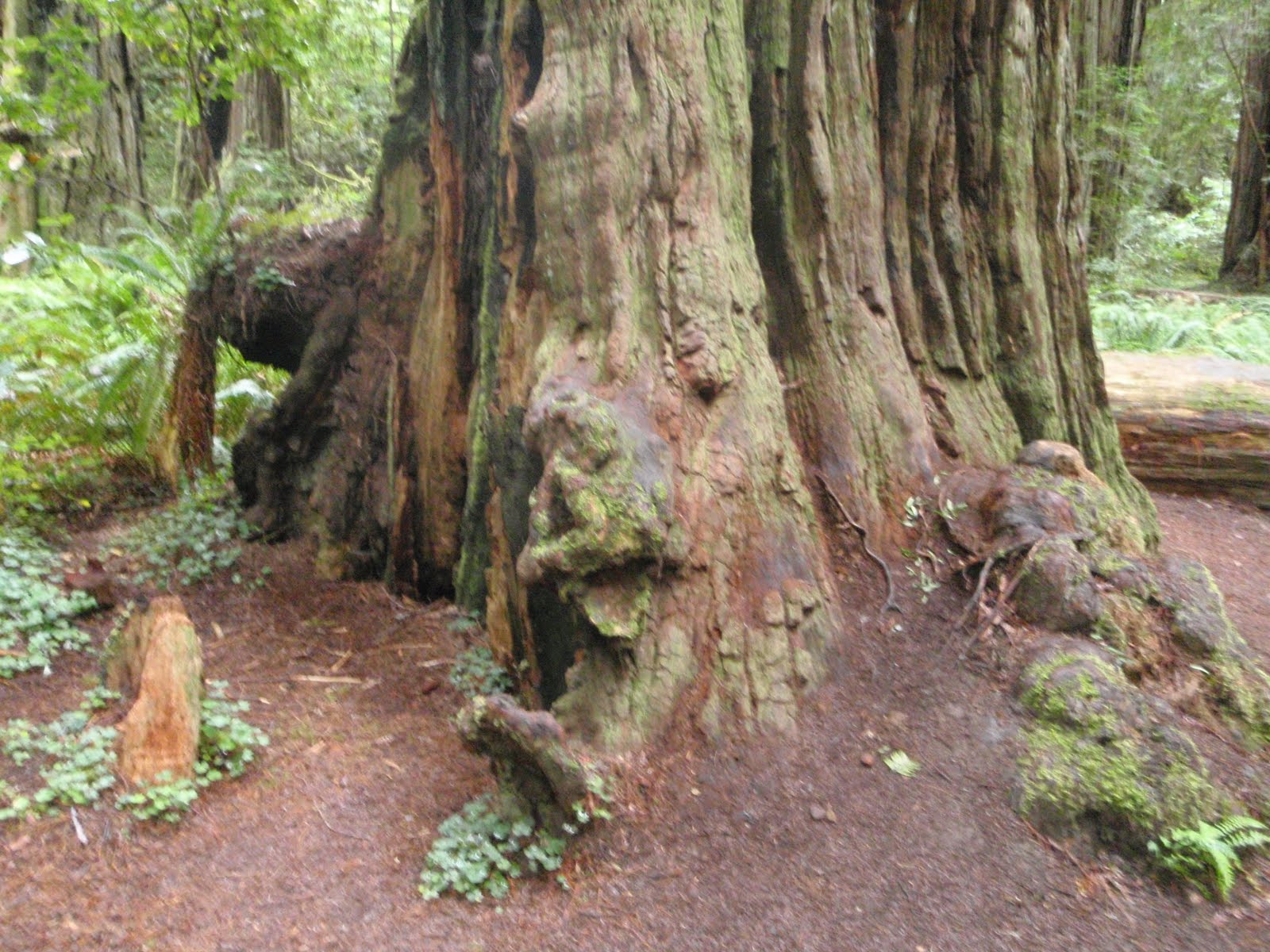
We saw the Founders Tree said to be 346 feet tall 
 and the even taller Dyerville Giant, said to be the tallest redwood tree in the world [362 feet] when a storm felled it in 1991.
  The Immortal Tree, which is thought to be at least 950 years old, has holes in the trunk big enough to walk through and what appears to be less than half its circumference yet is still alive and growing.
 We enjoyed the walk through the woods and the guide which a park service employee provided for us to use on site. After returning to the car, we left the park and returned to Highway 101 and headed toward Eureka. We took the exit for Ferndale and drove a farm-to-market road toward that town. We crossed the Eel River on a bridge built in 1911 and saw several dairies with hundreds of cows; these were mostly Jersey and not Holstein. Then we entered the Victorian town of Ferndale where we parked and walked up and down Main Street. The town retains its original store fronts and many of its Victorian style homes. Almost all the stores and most of the homes are restored with paint schemes accenting the ornate architectural details. We enjoyed eating some frozen yogurt and strolling the street before returning to the car. Retracing our route to Highway 101, we were soon back at the hotel
Sunday 17 July –We left Eureka shortly after 8:00. Driving north on Highway 101 through intermittent rain and drizzle gave an entirely different appearance to the scenery when contrasted with Friday’s drive over the same route. The colors no longer added dimension to the appearance of the sea and sky. In some areas, light fog provided ethereal wisps in the treetops. South of Crescent City, we exited the highway and headed toward Jedadiah Smith National Forest; we merged onto a park road which soon became unpaved, dirt, single-lane. This roadway wound among, around, and between redwood trees growing in the forest primeval. The overcast skies and drizzle only added to the feeling that we were among the first humans to see this area. Most of the trees had a radius of at least seven feet and tops that disappeared into the upper reaches of our range of sight.

 We parked and walked a half mile trail through Stout Grove. Here we felt even more like explorers as we heard the rushing river in the background and viewed the gigantic trees, many of which showed signs of decay. Ferns and moss thrived in the dampness. One tree was at least sixty-five feet around at the base! After returning to the car, we finished the loop and intersected Highway 199. Another stop at the Hiochi Information Center allowed us to purchase post cards. Neither they nor our photos do the redwoods justice because they can’t impart sensations.

 We parked and walked a half mile trail through Stout Grove. Here we felt even more like explorers as we heard the rushing river in the background and viewed the gigantic trees, many of which showed signs of decay. Ferns and moss thrived in the dampness. One tree was at least sixty-five feet around at the base! After returning to the car, we finished the loop and intersected Highway 199. Another stop at the Hiochi Information Center allowed us to purchase post cards. Neither they nor our photos do the redwoods justice because they can’t impart sensations.


 After intersecting Highway 101, we headed north toward Oregon. Without the appropriate signs, crossing the border is not really obvious except that the prosperity of Oregon as opposed to that of California becomes more apparent with each succeeding mile traveled. At Brookings, we stopped for lunch. Then we just continued enjoying the beautiful coastline of Oregon. High cliffs and huge boulders rising from the sea add mystique. Each twist and turn of the erose coastline added a new thrilling vista. We admired everything along the way. Just south of Bandon, we stopped at Vines Glassblowing Studio and did a little shopping. Then we stopped at Bandon Art Glass Studio and looked and shopped again before driving the seventy or so miles to Florence. Traffic was fairly light and even though there were signs indicating road construction, nobody worked on Sunday. Signs warning “Abrupt Edge” amused us. Huge sand dunes filled the area between the highway and the ocean; in fact, sand dune doesn’t even begin to evoke the proper image of these immense mountains of sand. In some areas, people rent four-wheelers and ride the dunes. There is even a surf park for surfing in the sand. We found the Best Western Pier Point Inn with little problem and checked into a room with a balcony overlooking the Siuslaw River. We relaxed for a while and I got cold sitting on the balcony. We drove into Old Town Florence and went to Resto Bar 1285 for dinner. Then we wandered around a little before returning to the room.
Monday 18 July – Even though the room is not air-conditioned, it is cool and comfortable. Around 10:00 when we left and headed back for Old Town Florence. We spent the day walking up and down the streets and wandering into and out of the shops. It sprinkled rain off and on but never enough to use our umbrellas. We enjoyed the coolness. Lunch at Bridgewater Zebra Bar was both delicious and relaxing. Afterwards, we drove back onto Highway 101 and plundered through some antique malls and stores before returning to the hotel to relax. We returned to Old Town Florence for dinner. After eating, we walked around the area for a while before driving back to the hotel.
Tuesday 19 July – This morning we again drove north on Highway 101. We soon left the sand dune terrain and entered a more mountainous one. We began to see monolithic rocks along the coast as well as beaches and crashing surf. We stopped a few times and made photos; one was of the Heceta Head Lighthouse.
 We drove much of the day sort of sandwiched between the mountains and the sea along a curving highway that went through many small towns. The speed limit was never more than 55 and often dropped to 20 in the towns; luckily, traffic was fairly light. We stopped at several glassblowing studios. As we drove farther north, the highway veered inland from the coast some. Valleys here provided pasture for dairy cattle---hundreds of Jerseys and Holsteins. We entered Tillamook and looked for a place to eat but couldn’t find one, so we stopped at a place advertising tourist information. It only had brochures but a lady waiting for a bus there told us about the cheese factory. We drove on through town and found the Tillamook Cheese Factory on the outskirts. We stopped and had sandwiches and drinks in the café there; then we enjoyed ice cream for dessert. The food was excellent and we enjoyed the hour or so spent there among a crowd of people. From there, we continued north on Highway 101, stopping a few times for photos---one on the slopes of Mt. Neahkahnie, at 1660+ feet the highest point on the Oregon coast---
 and glass studios, until we reached Astoria.. Around 6:00, we went to the Bridgewater Bistro and enjoyed an excellent meal in a converted cannery. The view of the Astoria Bridge and the Columbia River from the restaurant added to the meal’s enjoyment. Then we drove around a little. We drove up a steep mountainside alongside the courthouse until we reached the top. Then we headed along the ridge before driving even higher to reach the Astoria Column commemorating the westward expansion.
  We stopped and made some photos but didn’t climb the 164 steps to the top. From there, we descended to the river area and returned to the hotel.


Wednesday 20 July – We decided to drive the Astoria Bridge across the mouth of the Columbia River. We drove a curving, ascending ramp to reach the high level of the longest-single truss bridge and then drove across it; a lower span across some mud flats; another trussed span and reached Washington state. Then we made a u-turn and returned to Oregon.

We programmed the GPS for our destination in Salem, Oregon and began the drive. The first portion was a reverse of the previous day’s drive on Highway 101 as far as Seaside. From there we took Highway 26 east toward Portland. Driving for several hours through the Siuslaw National Forest is a very green experience---nothing but trees and no towns. The roadway was a good one and the drive fairly easy even though the mountainous terrain provided for lots of ups, downs, twists, turns. We were slowed a few times for bridge construction as there was only a one-lane roadway and each direction took turns; one of these announced that there was a “Twenty-Four Hour Flagger.” As we neared Portland, the flatter, more open land provided acreage for truck farming and we saw fields of vegetables and stands selling fresh cherries, strawberries, and other produce. After driving down to Salem, we reprogrammed the GPS and made it to The Fairfield Inn in Beaverton shortly before 3:00.
Thursday 21 July –We left shortly after 9:00 and drove to the park and ride lot. We used the credit card to purchase two all-day; all-zone tickets at $4.75 each and validated those tickets. Then we waited for the train. Other than my getting us off at the wrong stop, we made it into downtown and Pioneer Courthouse Square just fine. We purchased two tickets for the Big Pink Sightseeing Hop-On-Hop-Off Portland Trolley Tour and left that stop at 11:00; today’s schedule calls for about an hour between stops. The driver narrates and points out sites between stops. At the entrance to Washington Park, we saw the commemorative column dedicated by Theodore Roosevelt in 1905 to commemorate the centennial of the Lewis & Clark Expedition. We got off at the Portland Rose Garden stop inside the park and visited the Portland Japanese Garden, the most authentic Japanese garden outside of Japan. We walked the paved pathways and zig-zag-bridge as we made our way through the carefully manicured area.
 Some gardens are sand and stone with those elements raked into designs.

 Some gardens are sand and stone with those elements raked into designs.


 One pond contained koi.


In one area there is a stone engraved with a haiku.

After leaving this garden, we made some photographs of the rose garden before reboarding the trolley. This year’s cool, damp weather is not conducive to beautiful roses, and today’s overcast skies don’t allow a view of Mount Hood. 


The trolley took up to the top of the park on a road that skirted both the arboretum and the zoo before heading back down into the city. We got off at the stop in the Pearl District and went to Deschutes Brewery & Public House for lunch. After eating, we had about ten minutes to wait for the next trolley and rode it to Chinatown. This is a very small area and appears to have only bars and clubs in somewhat less-than-desirable appearing locations.  Chinatown Entrance Gate
 Chinatown Entrance Gate
Here we visited Lan Su Chinese Garden designed by a master from Suzhou, China and completed in 2000 by artisans from there. Almost all the materials came from China. The traditional Chinese style of courtyards and vistas through doorways and windows creates a tranquil effect. There is even a tea house. Two of the buildings contained exhibits of Chinese embroideries done by a company in the California using traditional Chinese methods. After leaving the garden, we wandered around a little and made a photograph of the traditional Chinese gate to the area before returning to the trolley stop. From that point on, we just rode. We did receive the bonus of waiting for the Hawthorne Bridge to be raised for a boat to pass under on the Williamette River. After disembarking at our beginning point, we caught the train out of downtown. 


 Tea House

 Scholar's Study


Friday 22 July –We chose Lloyd Center, a shopping mall, as a good place to kill some time before going to the airport. We wandered around for a while and then ate lunch before leaving. We used directions found online to locate a gas station near the airport. After filling up, we drove to Portland International Airport and turned in the rental car; we had driven 1286 miles. Then we entered the terminal and checked in. Security was easy and we made our way to the gate to wait for our flight; we left about on schedule. Today was the clear day for the trip with bright blue skies. We enjoyed the view of the mountains as we flew out; Mt. Hood stood especially tall like an upside down sno-cone cup. We could see at least two more snow-covered mountain tops, too. We flew down over the Rocky Mountains and enjoyed the many colors the sun created on them. The flight went well and when we landed at DFW a few minutes earlier than scheduled; the temperature was 95.